
NECROPOLIS of KAUNOS We are on the Dalyan River (ancient 'Kalbis'), the boundary between the two ancient civilizations ‘Lycia and Caria'. (In ancient times in Anatolia, the region between the Meander (Menderes) and Indus (Dalaman) rivers in the south was called Caria. The inhabitants were Carians and Lelegians. In his Iliad, Homeros describes the Carians as the natives of Anatolia, defending their country against Greeks in joint campaigns in collaboration with the Trojans. Caria and Lycia are so large territories, including many towns and villages and the name of the city of Caunos is mentioned as a land base between the two mentioned above. It is the center of a territory with the same name and includes a number of towns and villages under its control. The founders of the city are tribes of Anatolia.Foundation of Caunos: The king of the Caria, Milletos, who is the son of Apollo had twices. The boy twice is given the name 'Caunos', and the name of the girl baby is 'Byblis'. According to Ovidus (The Roman historian and poet), legend about the foundation of Caunos is like this: Byblis fell in love with her twin Caunos. Byblis wrote a letter to Caunos and told her feelings in her letter. Caunos reaction was very dissappointing for her and he refused her with hate and anger. The Caunos didn`t want to see Byblis again and left the country with his friends. He came to this region and founded the city that called with his name. As for Byblis, she wanted to die because of Caunos`s disappointing reaction to her love. She threw herself from a high hill but water fairies (Nympies) rescued her and reverted her to a river. The tears of Byblis formed the river and still that day, tears of her is splashing... That is the sad foundation story of Caunos. |
|---|
| The Carian language: The word of Caunos has no meaning in the Hellenic language. The name of the city of Caunos is Ksibde in Lycia and on the inscriptions of the urban environment, called as Kbid. With the help of an inscription written in two languages (ancient Carian and Greek) on a stele found in 1996 to Caunos, the Carian language and that of Caunos (which is a bit different), are decrypted. When the language of Caunos is resolved, it also confirmed that they used for their city the name of 'Kbid'. The letters B 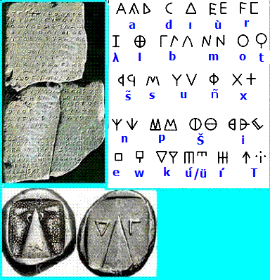 |
and K on the coins also became obvious what they mean; Kaunios basileus; the god of the cult of their ancestors. Although it fits the Carian language and alphabet, the five Kaunian letters were different.
Prof. Dr. M IŞIK who is the director of the excavation of Caunos, after Prof. Dr. M. Ogun, announced that they will begin the restoration works. During the archaeological excavations at Caunos, were obtained statues and pedestals, (lachrymatory) tear bottles, coins, the amhforas, diadems, earthenware and stoneware jewelry, vases, candles, some figures, ceramics and pots. |
|---|
Chronology ; Following archaeological excavations, it is understood that the history of Caunos dates back to around 3000 BC. We knew that the Carian and Lycian are the indigenous peoples of this region and we meet the names of these two civilizations in Hittite annals and in many Egyptian sources. The Carians as the Lycians participated in the war of Kadesh against Egipthiennes next to Hitits, in 1400 BC. In his Iliad, Homeros describes the Carians as the natives of Anatolia, defending their country against Greeks in joint campaigns in collaboration with the Trojans, in 1200 BC. Throughout history, Caunos has seen civilizations Lydian (VII. BC), Persian (546 BC.), Hellenistic (333 BC), Roman (II century BC- III. century AD.) and Byzantine (IV.-XIII. centuries AD.). After the XIIIth century, Caunos remained first in the state sovereignty Menteshogullari and then of the Ottoman Empire jousqu'à 1920. |
|---|
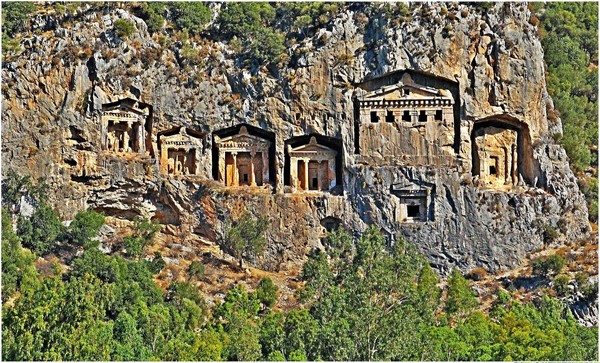 |
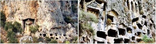
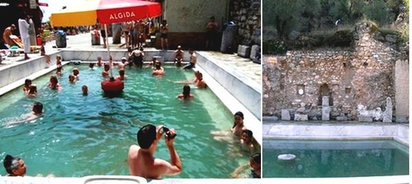
| THE ROCK TOMBS Necropolis - the Greek Necros, death and polished city, "city of the dead" - is a group of monumental tombs, which was a sacred place like temples.As in other ancient cities, there is also a large cemetery outside the settlement area in Caunos. The monumental rock tombs are, among the most striking remains, belonged to kings and loyal personalities. These tombs, which were carved in stone cliffs, are the symbol or the wealth and power of the ancient city Caunos. They are carved in the style of Lycian tombs. The rock was something sacred in Anatolia. It is the trace of a common heritage of ancient Anatolian Civilizations. In the funerary cult (in royal funerary cult ) (The mortuary cults), the Apside or Altar was a door opened in the deepness of the rock. Because the home of the Goddess, was the rock itself or the mountain itself representing the power (strength). This kind of construction formed from a religious thought. This is the thought to draw, to live, to expose, to see, a divine power on the strength of the rock. |
 |
|---|
| Here you see three different types of tombs. Some are like pigeons niches. They are the oldest and reflect the Persian culture (6th century BC). The dead, which can be estimated, were placed in the fetal position into the tombs. |
| Others are like wooden houses, one of the architectural style of antiquity; imitations of profiles of ‘Lycian wooden houses’. They date to the 5th and 4th century BC. | 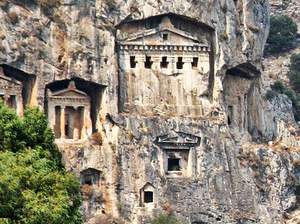 |
|---|
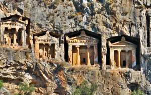 |
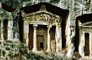
The third group of tombs, still 5th and 4th century BC, that attract attantion throughout their well-decorated facades, are in the shape of temples. They have a pediment (crowned gate) and behind the two Ionic columns, a simple burial chamber, with the seats located in it for the dead. These single rooms are cut to the rock face like a room of the temple. Many tombs were built with walls of false values behind them. |
|---|
| Here, we see only a relief of two lions, face to face, on the front of one of the temples graves. The Cover stones of the burial chambers, carved on site in the shape of the train compartment doors, are completely ruined. Two or three seats, one private sometimes, may be in the burial chamber. They were placed, in the middle of the room, the objects he used during his life or someone has brought after his death. All the tombs were emptied of their treasures at the Byzantine period. |
 |
|---|
| Funeral Traditions; the body of death is, dressed a long white shirt, oiled by the sacred oils, perfumed with the nice odors included the oil of "liquid amber". It was the custom that, before the funeral rites, a silver coin would be placed on his mouth, under the tongue, or on the eyes so he could pay the ferryman Charon to row him to the land of the dead. We do not know how long and how many slaves worked in the construction of tombs, but what kind of technique was used, can be estimated. They were used the platforms run with a pulley system, to dig the rock and to lay the dead. |
|---|
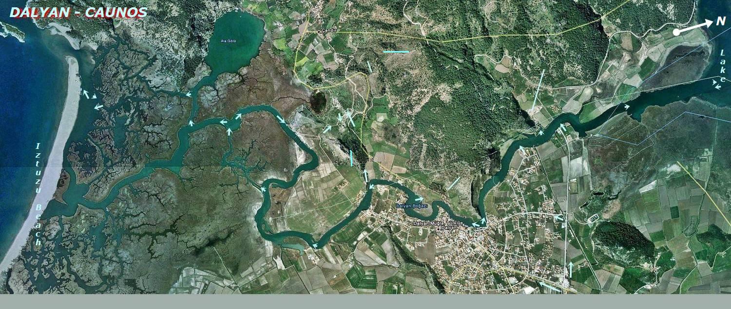
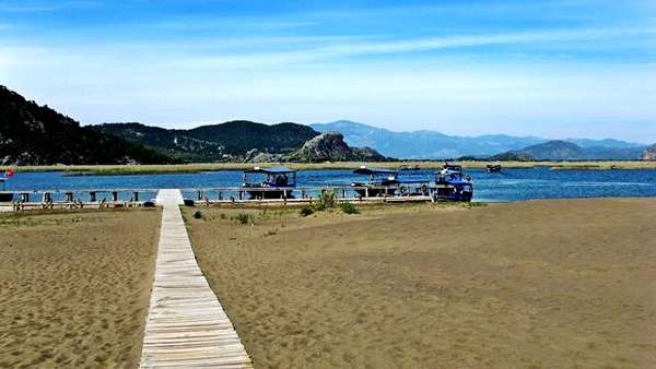
Iztuzu Beach : Iztuzu Beach, located at the junction of the Mediterranean Sea and the Dalyan River, the last stop of the boat ride, is 5400m long. Called as the Turtle Beach by foreigners, it is a fully protected area, but it is allowed to build two wooden cafes with cabins, toilets, and showers.The beach is reserved for the Carettas during summer nights between 20: 00 and 08:00, which gives us the opportunity to swim on both sides. Salinity in the river is less than the sea. The flow in the shallow groove at the end of the beach between the river and the sea is stronger. The area is accessible by organized boat trips as well as public boats called 'Dolmus'. |
|---|
 |
CARETTA CARETTA (Caouanne) : In English it is called a loggerhead turtle, Caretta Turtle. The origin of the word "Caret" is unclear, but it dates from the sixteenth century and a loan could be the languages of the Caribbean via Spanish. In New Caledonia, it is called "Big Head". The scientific term caretta is a Latinization of the term used by the French "Caret". |
|---|
It is a species of sea turtles rapidly receding, which is the subject of a local recovery plan. This species, few pelagic frequent usually temperate waters and sometimes tropical and subtropical waters. It is the only turtle nesting outside the tropics. Grouped by several hundred individuals, they are able to travel considerable distances from their site of life to reach the spawning grounds. In the Mediterranean sea, where there is five of the eight species of marine turtles, the loggerhead turtle is the most common species. It is also the most common turtle in the western Atlantic. Several nesting sites are known in the world and including in the eastern Mediterranean such as Turkey, Israel, Cyprus, the Ionian Islands, Tunisia, Libya and even in Sicily. In the western Atlantic, they will lay from Mexico to Virginia. |
The loggerhead turtle, carnivorous, feeding on many crustaceans and molluscs; it can weigh up to 160kg but the average weight of an adult is 105kg. It can measure 1.25m but average adults measured 1.10m. Dedicated to swim in open seas, the members of this large sea turtle serve both thrusters (front legs) and rudder (hind legs). Its shell is heart-shaped, flattened, its width is about 76% of its length. His head is long enough (about 28% of carapace length) and very large. Its carapace is reddish brown with light spots, his breastplate is pale yellow with orange spots diffuse. The new baby is black, like other sea turtles but its legs are clear. Like other marine turtles, the females lay their eggs only every two or three seasons. The age of sexual maturity is estimated at more than 10 years. Most loggerheads that reach adulthood live 30 years or over 50 years. |
Food: Their diet is predominantly carnivorous, and consists of mainly jellyfishs, crustaceans, shells, fishs, shellfishs and stingings. Reproduction: In the Mediterranean Sea spawning is from April to September on the sandy beaches. Females lay from dock for 4 to 7 times per season and deposit 64 to 198 eggs each time. The incubation period lasts 45 to 65 days. Unlike other sea turtles, mating usually takes place during migration and not near the spawning grounds. Referral system: When they leave their nest at birth land, sea turtles combine the perception of various signals for orientation. They are sensitive to light. Near the coast, where the water is shallow, this turtle is using probably the direction of the waves. From a distance, during migration and in the darkness of the deep sea, it stays the course, using Earth's magnetic field. These turtles are so sensitive to the flexibility as a function of magnetic field and its inclination. And very young loggerhead turtles placed shortly after hatching in pond reproducing conditions of magnetic field in other regions (Puerto Rico and Cape Verde, located in their normal migratory route at the same latitude (20 ° N), but at different longitudes) quickly oriented in the direction it would take in this environment (respectively to the NE and to the SE). At sea, it is accidentally captured by fishing nets. She is the victim of pollution from ingesting plastic bags that it confused with jellyfish. The future of this species in the Mediterranean sea depends primarily on the protection of nesting sites remaining in the eastern zone. Caretta, who fled to red colors, are separated, a long nose-black Nile turtles, still living here. |
Nile turtle (Trionyx triunguis) 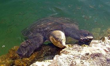 This is a location where the Nile turtle (Trionyx triunguis) can be spotted. It is a turtle with a soft shell, thence also called African softshell turtle, which is about 1m in size. It is a protected, thermophile species. Consequently it is often seen near the thermal springs along the fault line. The species occurs near to the sea, in lagoons, lakes, rivers and canals, both in fresh and brackish waters. The Nile turtle is mainly aquatic and will only leave the water for short periods to rest in the sun. In the Köyceğiz-Dalyan SEPA, oviposition takes place at the brackish waterside of İztuzu Beach. The Dalyan-Köyceğiz basin is in the utmost northwest of the species’ range. |
Without teeth, the Trionyx triunguis are carnivorous and eat mostly fish, worms and crabs. Their nose is like a short pipe and eyes on the front of the head. The Trionyx are active at night, you can see during the day while breathing, or sunbathing. Although they are breathing lung, their skin and respiratory have a particular structure. They can stay underwater for 15 hours. |
|---|
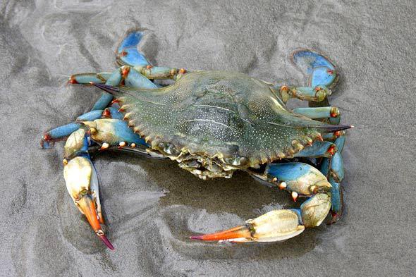
Blue crab - Callinectes (swimmer) sapidus (delicious): Japan imports 60% of the world crab. They are male-female-and child (teenager). Reproduction is in summer. The period of July the highest. 15 months after ovulation which become adults. (12-16 months). Feeding continues throughout the day, but especially in the morning and evening.The average lifespan of 2-4 years. The first pair of five pairs of legs is used as clamping and defense, the next three walking and the last swimming. (500 miles to 100 days). Lost limbs are always renewed. Shells, softened during the time of change, but within 72 hours, it becomes hard. For most small crabs, replacement of the shell is in every 3-5 days. ( female 18-20, male 25 times, total) and for each time they grow to 30 %.Females mate in a once a year.(during to the change of the shell.) |
|---|
 |
There are also private tours for 'Catching crab', as well as regular visits in Dalyan. 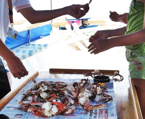 |
Mud Baths and Springs ; Dalyan has many therapeutic hot springs. The waters which contain radioactive elements and sulphur are believed to cure rheumatism, skin, liver, spleen and bowel complaints, as well as being beneficial for nervous, digestive disorders and gynecological problems.Mud bath is also for beauty and being younger. At list it is fun. Be sure to remove your silver jewelry and white gold. Colors can fade in water rich in sulfur. Once you have covered yourself in the mud, than you wait for few minutes to dry it, than wash them of the shower. Believers in the power of the mud say that the tightening effect of the drying mud is what makes the difference. Regular mud therapy can help deal with wrinkles while the healing waters of the spring are said to be the answer to sciatica, rheumatism and stomach problems. The mud bath, where generally foreign tourist get into the mud and have their photos taken, is always colourful and crowded but gives a good photo opportunity. You can immortalise this moment by posing for the camera before and after getting into the mud, which is supposed to have a beautifying effect on the skin but has also won a reputation engendering a sense of fun. It not only claims to have therapeutic properties (curing all manner of ills from skin problems to gastric conditions) but also claims to make you look ten years younger. |
|---|
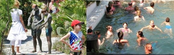 |
If you enjoy splashing around in the mud or wish to become more beautiful during your trip to Dalyan then the Mud Baths are your answer. The mud is said to have anti-ageing properties in that it removes your wrinkles, firstly cover your body in the mud and then bask in the sun while the mud bakes dry. As the mud dries it shrinks your skin removing your wrinkles with it. While it has not been scientifically proven to have this affect those that have tried it all believe themselves to have younger skin as a result. Failing any beauty affects many families enjoy the time wallowing in the mud on a hot day. Following your mud bath take a dip in the Thermal spring which has healing properties for the skin, respiratory system and rheumatism. |
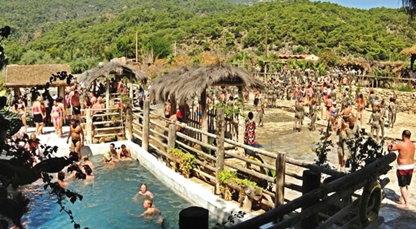 |
| Dalyan's mud baths are always popular. The baths have been a magnet for the rich and famous down the years and in recent times celebrities like Princess Caroline, Prince Charles, media emperor Robert Maxwell, Rockfeller, Dustin Hoffman, Sting, Jack Nicholson, David Bowie, and the Prince Felipe De Carlos of Spain have taken a dip on their visits here. |
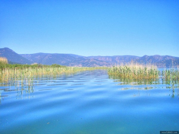
Lake Köyceğiz: Having an area of 5200 hectares, Lake Köyceğiz in the province of Muğla is one of the vastest coastal lakes of Turkey. It bears the name of the town of Köyceğiz, situated on its north bank. It is connected to the Mediterranean through a narrow and reedy channel. It joins the sea at İztuzu Beach. |
|---|
 |
| The depth of the lake varies from 20 to 60m. The lake is abundant with fish. In the lake there are five uninhabited islands, one of them known as Hapishane Adası (Prison Island). Initially the island was used for military purposes, then turned into a prison island. It is no longer in use. SULTANIYE THERMAL |
 |
The only spa resort, at Sultaniye, was restored in the 90’s and has been a popular tourist attraction ever since. The water temperature amounts to 40°C. Apart from the thermal spring, it also has a mud bath. |
 |
The lake was formed about 7500 years ago, when the entire eastern part of the Mediterranean was afflicted by earthquakes. At the south side of Köyceğiz Lake, there is a NW - SE fault line , bordered by several sulfurous hot springs, amongst others Sultaniye Spa. |
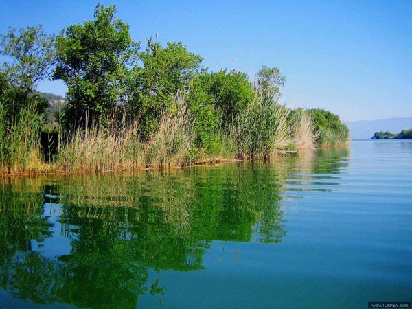 |
DALYAN The Dalyan trip is a journey full of natural beauties boats, sandy beach, sea turtles ‘Caretta’, blue crabs, history, rock cut tombs, hot springs and mud baths. The reason is that Dalyan is a wery interesting place. It is neither at the seaside nor near a lake. However, it belongs to a fine sandy beach, 5km in length, on the Mediterranean coast. On the western side of the area, the southern part of the Lake Koycegiz belongs to Dalyan, too. It is located on the left bank of the ancient Calbis river winding among the reeds from the lake to the Mediterranean Sea. The height difference between the lake and the sea is 1m. 38, and the natural channel is 14kms in length, from 50 to 70 m wide and 1m. 60 deep. Just on the other side of the Calbis river, the rock cut tombs of the ancient city of Kaunos are amazing. |
|---|
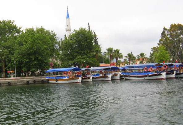 |
This interesting tour will continue, or with the pleasures of the beach in the salt waters of Iztuzu, or, in the hot springs, with a mud bath. Once you go up on the boat, the first thing to do is to give a good exposure to a young professional photographer of ‘Dalyan Photo Studio’, which will prepare for you a surprise memory ', and to write your desired order in the list for lunch. |
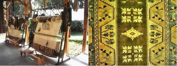
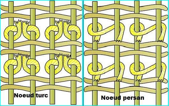
Carpet factory in DALYAN This is a cooperative of the carpet, 5km from Dalyan, in the village of OKÇULAR (means 'Archers'), where they do, to the groups of tourists, in their own languages, a presentation on the art of Turkish carpet weaving, that will be accompanied by an offer of apple tea or Turkish coffee at will.They inform the foreign tourists here, about the looms, the materials for carpet weaving, the root of making the paint from the natural ingredients, the difference between the Turkish and Persians knots etc. Then, they made in the 'showrooms' a demonstration of some fine examples of Anatolian carpets knotted by hand. |
|---|
 |
 |


